
Lesson 2 – Equatorial Coordinate System
Introduction
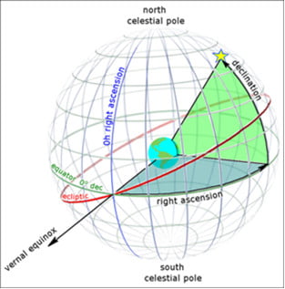
The Equatorial Coordinate System is a sophisticated grid system superimposed on the celestial sphere, serving as a fundamental framework for mapping the positions of celestial objects. This system divides the celestial sphere into two principal components: declination and right ascension. Declination, analogous to latitude on Earth, measures the angular distance of an object north or south of the celestial equator. Right ascension, similar to longitude, measures the object’s position eastward along the celestial equator. Together, these coordinates enable precise and consistent location of stars, planets, and other celestial bodies, facilitating accurate astronomical observations and research.
I. What is the Equatorial Coordinate System?
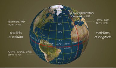
The Equatorial Coordinate System is a method used to find the position of objects in the night sky based on their relationship to the Earth’s equator. It is similar to the latitude and longitude systems used to locate places on Earth’s surface. In this system, the Celestial Equator acts as the Earth’s equator, dividing the sky into northern and southern hemispheres. Declination, which is similar to latitude, measures the distance of an object from the Celestial Equator in degrees. Right Ascension, similar to longitude, measures the eastward distance of an object from a fixed point known as the vernal equinox. These coordinates are used by astronomers to precisely locate celestial objects in the sky.
The Equatorial Coordinate System is crucial in astronomy because it enables scientists to locate objects in the night sky regardless of their position on Earth’s surface. This means that astronomers from different locations can accurately communicate and study the same objects. By using this system, astronomers can track the movement of celestial bodies, measure their distances, and observe changes in their positions over time. Once the coordinates of an object are known, it becomes easier to locate it on star maps or telescopes. Therefore, the Equatorial Coordinate System is an essential tool for astronomers studying the vast and captivating universe.
II. Celestial Coordinates Importance
Celestial coordinates are a vital tool that astronomers use to find and study objects in the night sky. These coordinates act like an address, allowing astronomers to pinpoint the exact location of stars, planets, and other celestial bodies. There are two main systems of celestial coordinates: equatorial coordinates and ecliptic coordinates.
Equatorial coordinates are based on the Earth’s equator and the celestial equator, an imaginary line above the Earth’s equator. They consist of two measurements: declination and right ascension. Declination is similar to latitude on Earth and tells us how far north or south an object is from the celestial equator. Right ascension, on the other hand, is similar to longitude and gives us the east-west position of an object. With these coordinates, astronomers can easily find celestial objects and study their movements over time.
Ecliptic coordinates, on the other hand, are based on the Earth’s orbital plane around the Sun. These coordinates are particularly important for tracking the positions of the Sun, Moon, and planets, as they follow the same path in the sky called the ecliptic. They also consist of two measurements: celestial latitude and celestial longitude. Celestial latitude tells us the north-south position of an object relative to the ecliptic, while celestial longitude indicates the object’s position east or west of the vernal equinox. By using these coordinates, astronomers can accurately predict the positions of the Sun, Moon, and planets throughout the year.
Understanding celestial coordinates is crucial for astronomers to navigate and study celestial objects effectively. Equatorial and ecliptic coordinates provide a universal system for locating and tracking these objects, helping astronomers unravel the mysteries of the universe. Whether it’s observing distant stars or predicting the movements of planets, celestial coordinates play a vital role in our exploration of the cosmos.
Conclusion
In conclusion, the Equatorial Coordinate System is a crucial and foundational tool in the field of astronomy, meticulously designed to describe and map the positions of celestial objects in relation to the Earth. By employing the coordinates of declination and right ascension, this system provides astronomers with a consistent and precise method for locating stars, planets, and other celestial phenomena. Its structure, mirroring the Earth’s latitude and longitude system, allows for seamless integration and comparison of observations from different locations and times. This makes the Equatorial Coordinate System indispensable for both professional astronomers conducting research and amateur stargazers exploring the night sky.