
Lesson 1 – Horizon Coordinate System
Introduction
The Horizon Coordinate System is an indispensable tool for astronomers and stargazers, enabling them to accurately pinpoint and monitor the positions of celestial objects in the sky. This system allows for the precise location and tracking of stars, planets, and other astronomical phenomena relative to the observer’s local horizon. By utilizing this method, stargazers can effortlessly find and follow celestial bodies with remarkable accuracy. Whether one is observing a distant star or tracking the movement of a planet, the Horizon Coordinate System provides a straightforward and effective means of navigation, making it an essential component of modern astronomy.
The Horizon System
The Horizon Coordinate System is a method developed by astronomers to assist in locating and describing objects in the night sky. It simplifies the understanding and navigation of the vastness of space by using relatable and easy-to-understand terms, rather than complex mathematical equations or coordinates. It can be likened to a sky map that guides us through the stars and planets.
When we gaze up at the sky, we perceive a dome-like shape known as the celestial sphere, which serves as the foundation for the Horizon Coordinate System. Imagine yourself standing at the center of a colossal sphere, with your head positioned there. This dome encompasses everything visible above the horizon. To aid in locating objects in the sky, the Horizon Coordinate System divides this celestial sphere into sections and assigns them names.
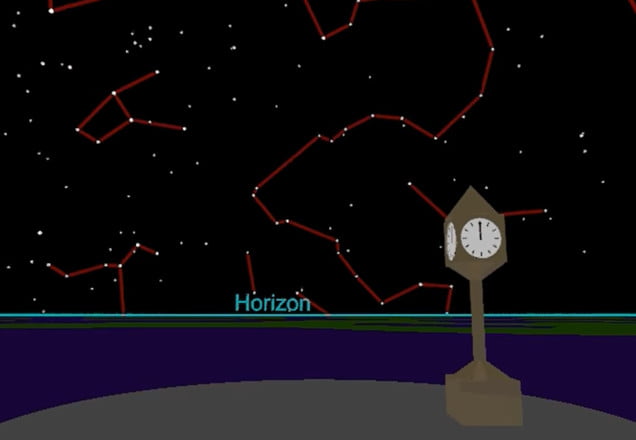
The first division is the horizon, which represents the line where the sky appears to meet the Earth. It resembles the edge of the dome we stand within. When we mention an object being on the horizon, we mean it is just barely visible at the outermost part of our field of view. The horizon acts as the starting point for the Horizon Coordinate System and assists in determining the other divisions.
The meridian is a crucial component of the Horizon Coordinate System. It is an imaginary line that starts from the north point on the horizon, passes through the zenith (the point directly above us), and extends to the south point on the horizon. This line serves as a reference for all other measurements in the system.
To facilitate navigation of the celestial sphere, astronomers have divided it into two main sections: the northern hemisphere and the southern hemisphere. These sections are named after the Earth’s hemispheres and are determined by our location on the planet. If we are in the northern hemisphere, everything above the celestial equator is considered the northern sky, and the opposite applies to the southern hemisphere.
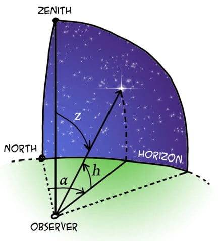
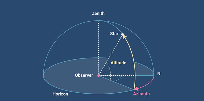
The Horizon Coordinate System is a useful way to measure the position of objects in the sky. It uses three main measurements: altitude, azimuth, and the meridian. Altitude measures the height of an object above the horizon, and it is measured in degrees. The highest altitude an object can have is 90 degrees, which means it is directly above us. The lowest possible altitude is 0 degrees when the object is right on the horizon.
Azimuth refers to the direction an object is located from the meridian. It is also measured in degrees, with 0 degrees being north, 90 degrees east, 180 degrees south, and 270 degrees west. By using altitude and azimuth, we can determine the exact location of an object in the night sky.
The Horizon Coordinate System is a user-friendly way for astronomers and stargazers to navigate the sky. It breaks down the sky into understandable divisions and uses relatable terms like the horizon, meridian, altitude, and azimuth to locate objects. It is similar to using a map to find our way in unfamiliar places. With the Horizon Coordinate System, we can explore and appreciate the wonders of the night sky.
Conclusion
In conclusion, the Horizon Coordinate System is an essential and fundamental tool in the field of astronomy, employed to ascertain the precise position of celestial objects relative to an observer’s specific location on Earth. By taking into account the observer’s local horizon and employing measurements of altitude and azimuth, this system allows astronomers and stargazers to accurately locate and track stars, planets, and other celestial phenomena. Its intuitive nature and practical applicability make it an invaluable resource for both amateur stargazers and professional astronomers, facilitating a deeper understanding of the night sky and the movements of the heavens.