
Lesson 1 – Five Themes of Geography
Introduction
The Five Themes of Geography serve as a powerful tool for understanding and analyzing the intricate dynamics of our world. Just as a compound microscope magnifies small objects to reveal hidden details, the Five Themes of Geography—Location (where a place is on Earth), Place (its unique physical and human characteristics), Human-Environment Interaction (how people and the environment affect each other), Movement (the flow of people, goods, and ideas), and Region (areas defined by shared traits)—allow us to explore the complexities of our planet. These themes are not just theoretical; they have practical applications in urban planning, environmental conservation, and disaster management. Understanding geography through these lenses enhances our ability to make informed decisions in everyday life, from choosing where to live to responding to global challenges. In this lesson, we will explore the definition and significance of each theme, see how they work together to offer a comprehensive understanding of geography, and gain insights into the diverse landscapes, cultures, and interactions that make up our global tapestry. Get ready to enhance your geographic vision as we embark on this enlightening journey through the Five Themes of Geography.
I. Definition:
The Five Themes of Geography were developed in 1984 by the National Council for Geographic Education (NCGE) and the Association of American Geographers (AAG) as a way to standardize and organize the teaching of geography in schools. Before the introduction of these themes, geography education in the United States lacked a unified structure, which made it challenging for students to grasp the interconnectedness of geographic concepts. The Five Themes—Location, Place, Human-Environment Interaction, Movement, and Region—were introduced to provide a framework that would help students better understand the world by categorizing and exploring the essential elements of geography.
The significance of the Five Themes lies in their ability to simplify and systematize complex geographic information, making it more accessible and easier to teach. By breaking down geography into these five distinct, yet interconnected themes, educators can help students develop a deeper understanding of how different aspects of the world are related. This framework also encourages students to think critically about the spatial relationships and patterns that influence human activity and the natural environment, fostering a more holistic understanding of global issues.
The Five Themes of Geography have had a lasting impact on geography education, serving as a foundational tool in classrooms for decades. They continue to be relevant in helping students and educators explore the relationships between people, places, and the environment, offering insights that are crucial for addressing contemporary challenges such as urbanization, climate change, and globalization.
1. The 5 Themes of Geography
When students learning about the Five Themes of Geography might suffer from several misconceptions that can hinder their understanding. For instance, they may assume that each theme operates independently, not realizing that the themes are interconnected and often overlap in real-world scenarios. Another common misconception is that Location refers only to the absolute coordinates of a place, neglecting the importance of relative location, which describes a place’s position in relation to other locations. Addressing these misconceptions is crucial for a comprehensive understanding of geography.
1.1. Location
Location is a fundamental theme in geography that focuses on identifying and describing where something is on the Earth’s surface. It can be expressed in terms of absolute location, using coordinates such as latitude and longitude, or relative location, which describes a place’s position about other places. Understanding location helps us orient ourselves, navigate the world, and analyze the spatial relationships between different places.
Example:
The coordinates of New York City (approximately 40.7128° N latitude and 74.0060° W longitude) pinpoint its absolute location on the Earth's surface. Relative location can be described as New York City being situated on the northeastern coast of the United States, about 225 miles southwest of Boston
1.2. Place
Place
The theme of Place explores the unique characteristics and attributes of a location. It goes beyond physical features and considers human and cultural aspects as well. Place encompasses the natural environment, such as landforms, climate, and ecosystems, as well as human-made features like buildings, infrastructure, and cultural landmarks. However, places are not static; they change over time due to a variety of factors. Natural processes such as erosion, climate change, and natural disasters can alter the physical landscape, while human activities like urbanization, deforestation, and industrialization reshape the built environment and cultural aspects. Migration, trade, and technological advancements also play significant roles in transforming a place’s identity, as new people bring different customs, languages, and innovations. Additionally, economic shifts, political decisions, and social movements such as the impact of the Industrial Revolution can lead to the redevelopment or rebranding of places, altering their significance and how they are perceived by both residents and outsiders. By examining the physical and cultural characteristics of a place, along with the factors that influence its changes over time, we gain deeper insights into its evolving identity, significance, and the experiences of the people who inhabit it.
Example
The Great Wall of China is a distinctive feature of northern China, making it a unique place. It’s characterized by its massive stone and earth structure, its historical significance as a defense against invasions, and the surrounding mountainous terrain. The human aspects include the cultural significance of the wall and the historical architecture that reflects ancient Chinese civilization.
1.3. Human-Environment Interaction
This theme examines the dynamic relationship between humans and their environment. It explores how people adapt to, modify, and depend on their surroundings. Human-Environment Interaction encompasses a range of activities, including agriculture, resource extraction, urbanization, pollution, and conservation. Understanding this theme helps us comprehend the impact of human actions on the environment and how the environment, in turn, influences human societies.
Example
The Netherlands is known for its extensive system of dikes and canals, which demonstrate how humans have adapted to living below sea level. The Dutch have altered their environment to prevent flooding and reclaim land from the sea, showing a significant interaction between humans and their environment.
1.4. Movement
Movement refers to the mobility of people, goods, and ideas across the Earth’s surface. This theme examines the patterns, processes, and consequences of movement at different scales, from local to global. It encompasses various forms of movement, such as migration, trade, communication, transportation, and the diffusion of cultural practices and innovations. Analyzing movement helps us understand the interconnectedness and interdependence of societies, economies, and cultures around the world.
Example
The global trade of coffee illustrates movement. Coffee beans are primarily grown in countries like Brazil, Vietnam, and Colombia, and then exported worldwide, including to the United States and Europe. This movement of goods involves not only the physical transportation of coffee but also the exchange of ideas, culture, and economic resources.
1.5. Region
Region focuses on the organization and categorization of the Earth’s surface into distinct areas with common characteristics. Regions can be defined by physical features, such as mountain ranges or climate zones, as well as cultural, economic, or political attributes, such as language, industry, or governance. They provide a framework for understanding spatial patterns, identifying similarities and differences between places, and studying the processes that shape different areas. Regions can be formal, based on administrative boundaries like countries or states, or functional, defined by interactions and connections, such as a metropolitan area influenced by a central city.
However, regions often overlap, which can complicate geographic analysis. For example, a cultural region defined by language might span across multiple political regions, like the Francophone regions of Canada and France. Similarly, an economic region based on trade networks might overlap with several formal political regions, such as the European Union’s single market encompassing multiple countries. These overlapping regions can lead to complex interactions, where different influences converge and create unique challenges and opportunities. For instance, policies implemented within a political region might have varying impacts across overlapping economic or cultural regions, requiring nuanced approaches to governance, resource management, and development. Understanding how regions overlap and interact is crucial for accurately analyzing geographic patterns and addressing issues that arise from these intersections.
Example
The Middle East is a region defined by its common cultural, linguistic, and religious characteristics, such as the predominance of Arabic language and Islam. It includes countries like Saudi Arabia, Iran, and Egypt, which share certain climatic and historical traits, making it a distinct region within global geography.
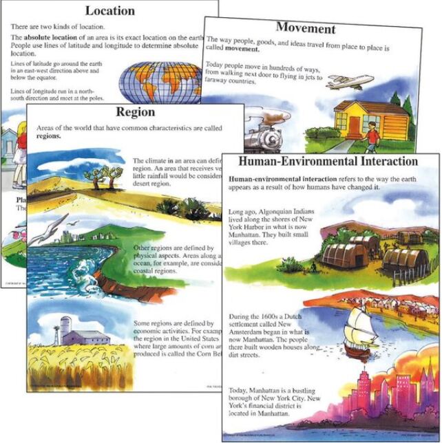
Figure 1: 5 themes of geography projects
II. How to Introduce Basic Geography Skills in Your Social Studies Classroom
1. Introduce Basic Mapping Skills
Begin by starting with simple maps that feature familiar landmarks or areas that students can easily relate to. This approach helps students grasp essential map terminology, such as coordinates, latitude, longitude, legend, and scale. Engage students in discussions about the compass rose and provide opportunities for them to practice with directions. This initial step enhances their understanding of maps as tools for navigation and exploration. Next, help to approach students to use Google Earth to measure distances between different locations, comparing the results to their estimates. Have them create “map stories” by plotting a route or journey, adding descriptions and images at each stop to explain the significance of the places they encounter. Additionally, introduce students to 3D terrain views, where they can explore the topography of mountains, valleys, and other landforms, deepening their understanding of physical geography. Finally, challenge students to investigate the impact of human activities on the environment by comparing satellite images of the same area taken at different times, fostering discussions about urbanization, deforestation, or climate change.
2. Use Different Types of Maps
Thematic maps are essential tools for visually representing specific data, such as population density or economic activity, in a geographic context. Unlike general maps, which show various features, thematic maps focus on one subject, making complex data easier to understand and analyze. For example, a population density map highlights areas of high and low population, revealing patterns like urbanization and migration. Similarly, a map of economic activity shows the distribution of industries or GDP across regions, helping to identify economic hubs and regional contributions. Thematic maps make spatial relationships and trends more apparent, aiding decision-making in fields like urban planning, economics, and environmental science.
3. Teach with Charts and Graphs
Extend geography skills beyond maps by introducing charts and graphs that display information related to geographical concepts. Show students how charts and graphs can convey data that is also available on maps, reinforcing their understanding of geographic information representation. Utilize charts and graphs to provide visually accessible information that students can analyze and reference.
4. Utilize Text to Reinforce Geographic Skills
To deepen student understanding and connect their geography/mapping skills to concrete information, incorporate text passages and historical documents. By analyzing and interpreting written information alongside maps, students can make connections and develop a comprehensive understanding of geographical contexts. Assess student comprehension by integrating text-based questions and mapping exercises.
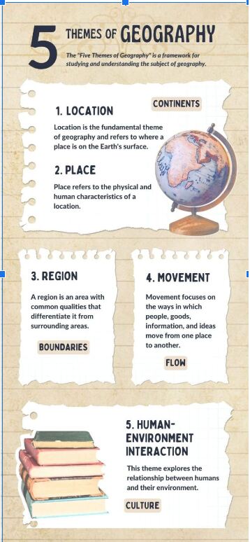
Figure 2: Teaching 5 themes of geography
III. Five Activities for Teaching Geography’s Five Themes
1. Location Treasure Hunt
Create a location-based treasure hunt activity where students use maps and coordinates to find hidden objects or landmarks within the school or local area. Provide clues and hints that require students to apply their knowledge of latitude, longitude, and cardinal directions. This activity helps students practice using coordinates and reinforces their understanding of absolute and relative location.
Example:
Use coordinates to locate famous landmarks.
Instructions
- Provide students with the latitude and longitude of various global landmarks, such as the Eiffel Tower (48.8584° N, 2.2945° E) or the Statue of Liberty (40.6892° N, 74.0445° W).
- Have them use a map or digital tools like Google Earth to pinpoint these locations.
- Students can then describe the relative location of each landmark, explaining its position in relation to nearby cities or geographical features.
2. Creating Collage of Place
Assign students a specific place or region and ask them to create a collage that represents its unique physical and cultural characteristics. They can use pictures, magazine cutouts, and drawings to depict aspects such as landforms, climate, vegetation, architecture, and cultural symbols. This activity allows students to explore the concept of place and develop visual representations of the diverse characteristics that define a particular location.
Example
Create a profile of your local community.
Instructions
- Students explore their local area, taking photos or drawing pictures of significant physical features (e.g., rivers, parks) and human characteristics (e.g., buildings, monuments).
- They then compile this information into a presentation or poster that describes what makes their community unique.
- Encourage students to include cultural aspects, like local festivals or traditions, to show the full character of their place.
3. Human-environment Interaction Case Studies
Divide students into groups and provide them with case studies that focus on different human-environment interactions, such as deforestation, urbanization, or water management. Each group analyzes the case study and prepares a presentation or poster that highlights the interactions, impacts, and possible solutions. This activity promotes critical thinking and encourages students to examine the complex relationships between human activities and the environment.
Example:
Investigate and propose solutions to local environmental issues.
Instructions
- Assign students to identify an environmental issue in their area, such as littering, water pollution, or deforestation.
- They research the causes and effects of the problem and use mapping tools to show affected areas.
- Students then brainstorm and propose practical, eco-friendly solutions, presenting their ideas to the class.
4. Movement Mapping
Have students create a visual representation of movement by mapping the flow of goods, people, or ideas between different regions or countries. They can use arrows, labels, and colors to illustrate the patterns and connections. This activity helps students understand the significance of movement in shaping cultural diffusion, trade networks, migration, and other global interactions.
Example
Trace the migration of a specific group of people.
Instructions
- Students choose a group of people, such as refugees from Syria or Irish immigrants during the 19th century.
- They research the reasons for migration, the journey taken, and the impact on both the place of origin and the destination.
- Using a map, students trace the migration route and create a timeline of key events, highlighting the movement of people and its effects on different regions.
5. Regional Comparison Project
Assign students different regions or countries and have them conduct research to compare and contrast various aspects such as climate, natural resources, economic activities, cultural practices, and population distribution. Students can present their findings using charts, graphs, and maps, highlighting the similarities and differences between the regions. This activity promotes an understanding of regions as distinct areas with unique characteristics and fosters a broader perspective on global diversity.
Example
Compare two different regions based on climate, culture, or economy.
Instructions
- Select two regions with distinct characteristics, such as the Amazon Rainforest and the Sahara Desert.
- Students research each region’s climate, physical geography, culture, and economic activities.
- They create a comparison chart or Venn diagram to illustrate similarities and differences, discussing how these factors define each region and influence life there.
IV. Frequently asked Questions
- What is the significance of the theme of Location in geography?
Answer: The theme of Location focuses on identifying and describing where something is on the Earth’s surface. It helps us understand the spatial relationships between places, navigate the world, and analyze patterns and connections. Location can be expressed in terms of absolute coordinates or relative positions, providing a foundation for understanding geographic features and phenomena.
2. How does the theme of Place contribute to our understanding of geography?
Answer: The theme of Place explores the unique characteristics and attributes of a location. It goes beyond physical features and encompasses the human and cultural aspects as well. Understanding Place allows us to examine the physical environment, human-made features, and the cultural, economic, and social attributes that shape a specific area.
3. How do the Five Themes of Geography help us develop a global perspective?
Answer: The Five Themes of Geography provide a comprehensive approach to studying the world, enabling us to develop a broader and more interconnected understanding. By examining the themes of Location, Place, Human-Environment Interaction, Movement, and Region, we gain insights into how different regions, cultures, and environments are interconnected, fostering a global perspective that considers the complexities and interdependencies of our planet.
4. How is the theme of Location used in real-world situations?
Answer: Location is crucial in navigation, disaster response, and logistics. For example, emergency services use absolute location (coordinates) to quickly reach a disaster site, while businesses use relative location to select optimal locations for new stores based on proximity to customers and competitors.
5. Why is understanding Place important for urban planning?
Answer: Understanding Place helps urban planners consider both physical and cultural characteristics when designing cities. This includes respecting historical landmarks, designing infrastructure suited to the local climate, and accommodating cultural practices within public spaces.
6. How does the theme of Human-Environment Interaction inform environmental policies?
Answer: This theme helps policymakers understand the impact of human activities on the environment and vice versa. For example, by studying how farming practices affect soil quality or how coastal development increases flood risk, policies can be created to promote sustainable land use and mitigate environmental damage.
Conclusion
The Five Themes of Geography provide a comprehensive framework for understanding the complexities of our world. Through the themes of Location, Place, Human-Environment Interaction, Movement, and Region, we gain valuable insights into the spatial patterns, connections, and dynamics that shape our planet. These themes allow us to analyze and interpret the diverse landscapes, cultures, and interactions that make up our global tapestry. By delving into each theme, we develop a deeper appreciation for the interconnectedness of our world, the impact of human activities on the environment, the significance of movement and cultural diffusion, and the unique characteristics of different regions. As you continue to explore these themes, consider how they apply to the world around you and think about ways to use this knowledge to address real-world challenges, whether in urban planning, environmental conservation, or global trade. The journey through geography doesn’t end here—it’s an invitation to keep discovering, questioning, and applying what you’ve learned to make a meaningful impact.